Kata Tjuta
Kata Tjuta
Kata Tjuta, 36 sacred sandstone domes of the Anangu people, 45 minutes from Yulara. History, hikes through the Valley of the Winds and Walpa Gorge, access and best seasons.
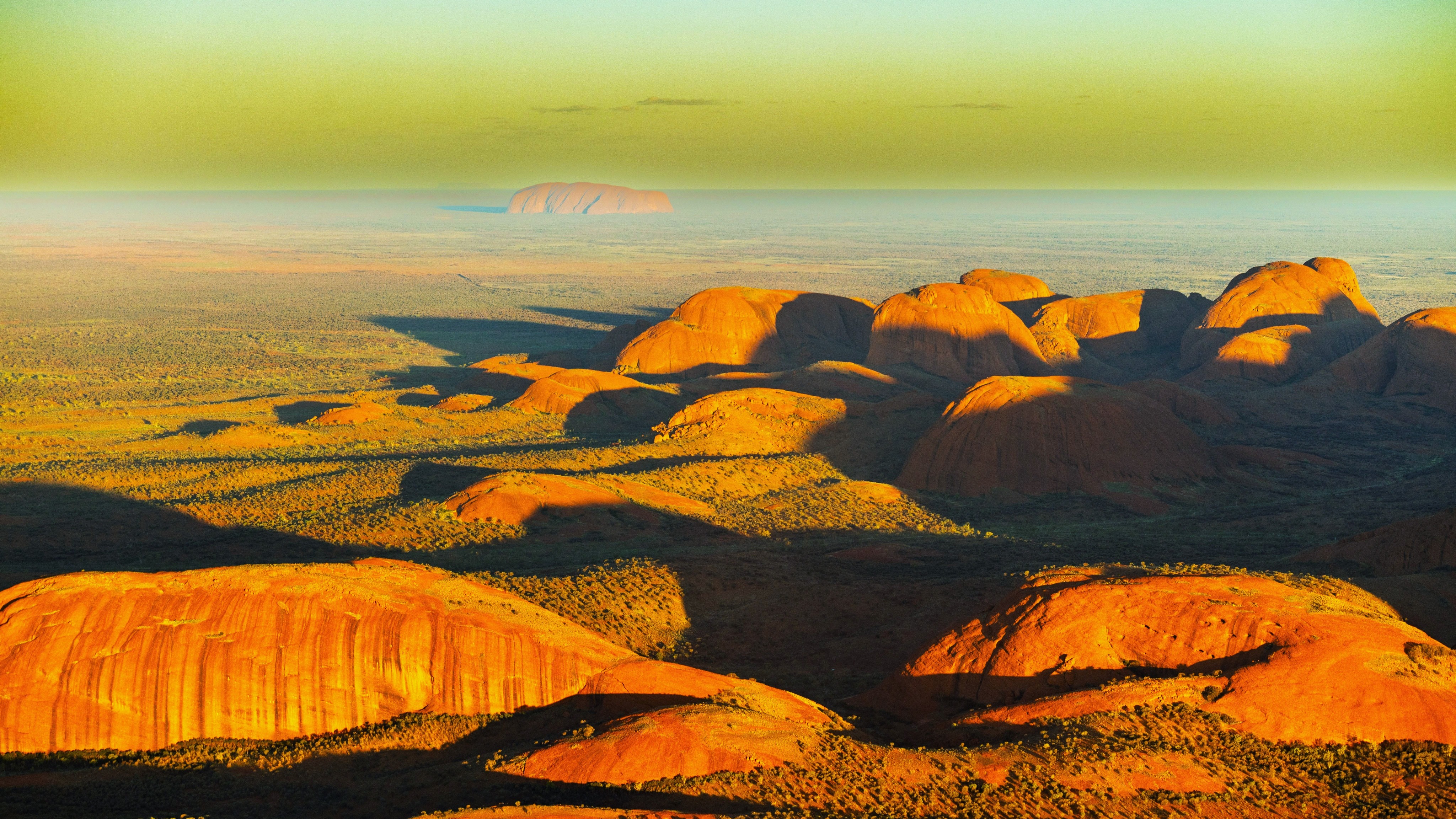
Kata Tjuta, meaning "many heads" in Pitjantjatjara, encompasses 36 sandstone and conglomerate domes rising from the red desert of the Northern Territory, roughly 50 kilometres west of Uluru. The massif is part of Uluru-Kata Tjuta National Park, jointly owned by the Anangu people and the Australian state, and ranks among the major natural and cultural sites in central Australie. Yulara, 45 minutes' drive away, serves as the logistical base for visits.
Why visit Kata Tjuta
Often overshadowed by Uluru, Kata Tjuta offers comparable landscapes without the crowds that accompany its neighbour. The domes reach 546 metres above the plain (Mount Olga), nearly 200 metres higher than Uluru. The site presents three complementary strengths:
- Singular geology: 500-million-year-old conglomerates, eroded into rounded forms.
- Living cultural significance: Kata Tjuta remains a sacred site for Anangu men, where certain ceremonies continue to take place.
- Two hiking trails of varying difficulty that allow you to approach the domes rather than simply admire them from afar.
History of Kata Tjuta
Long before Europeans arrived, the Anangu lived on these lands following the Tjukurpa, the spiritual law that connects people, land and ancestors. This oral tradition, transmitted through stories, songs and sacred routes, continues to structure their relationship with the territory today.
In the 19th century, construction of the Overland Telegraph Line opens central Australie to European exploration. In 1872, Ernest Giles discovers the massif and names it the Olga Mountains, in homage to Queen Olga of Württemberg. The following year, William Christie Gosse identifies another inselberg: Ayers Rock, now known as Uluru.
The establishment of farms and pressure on resources subsequently transform Anangu ways of life. In 1920, part of the area becomes an Aboriginal reserve, followed by the creation of a national park in 1958. The turning point comes in the 1970s: the Aboriginal Land Rights Act (1976) officially recognises the land rights of Indigenous peoples. In 1985, the Uluru-Kata Tjuta lands are returned to the Anangu, who become co-owners and co-governors of the park alongside the national parks service. The site is inscribed on the UNESCO World Heritage List in 1987 for its natural value, then in 1994 for its cultural significance.
What to see and do
Uluru-Kata Tjuta Cultural Centre
Located near Uluru, it serves as the logical starting point for your visit. The exhibitions present the Tjukurpa, Anangu art and the park's history. Photography is discouraged out of respect for the traditional owners.
The Dunes Viewpoint
On the road leading to the domes, a walk of around 600 metres to a viewpoint from the dunes area offers an overview of the massif. This spot is particularly rewarding at sunrise and sunset, when the low-angle light intensifies the reddish hues of the sandstone.
Valley of the Winds
An emblematic trail in the park, the Valley of the Winds—a trail of around three hours—passes through several domes and reaches two successive viewpoints (Karu Lookout, accessible quickly, and Karingana Lookout, more challenging). The terrain is rocky and sometimes steep. Bring sturdy walking shoes and at least 1.5 litres of water per person.
Walpa Gorge
Shorter (around 2.6 km return, 1 hour), the Walpa Gorge walk follows a stone corridor between two of the tallest domes. The cleft shelters denser desert vegetation, sometimes a seasonal stream after rainfall.
When to visit
Climate strongly influences the experience.
- May to September (Australian winter): the most favourable period. Dry days around 20–25°C, cold nights (sometimes near 0°C). Ideal conditions for hiking.
- October and April (shoulder seasons): temperatures still comfortable but rising rapidly.
- November to March (Australian summer): extreme heat, frequently above 38°C. Rangers close the Valley of the Winds above 36°C, generally before 11 a.m. Flies are abundant: a head net is recommended.
Whatever the season, it's best to hike in early morning.
Practical information
- Park pass: entry to Uluru-Kata Tjuta National Park is charged (moderate fee, valid for three days). Tickets can be purchased online via the Parks Australie website or at the park entrance.
- Hours: the park opens before sunrise and closes after sunset, with times varying by season.
- Equipment: walking shoes, hat, high-SPF sunscreen, water in quantity (1.5 to 2 litres per person for the Valley of the Winds), insect head net from October to April.
- Accommodation: Yulara (Ayers Rock Resort) houses all hotels, campsites and services in the region.
- Respect for sacred sites: certain areas are off-limits for photography or public access. Signs on-site make this clear.
How to get there
- By air: Ayers Rock Airport (Connellan Airport), roughly 50 minutes drive from the park. Served from Sydney, Melbourne, Brisbane, Cairns and Alice Springs. Shuttles and car rentals are available on arrival.
- By car: from Alice Springs, around 4.5 hours via the Stuart Highway (N87) then the Lasseter Highway (A4). Sealed roads throughout the journey.
- From Yulara: allow 45 minutes from Yulara via Kata Tjuta Road. Shuttles and guided tours run daily between Yulara, Uluru and Kata Tjuta.
Nearby
- Uluru: 50 km away, the park's other inselberg, whose base walks and sunset sites logically complement a visit to Kata Tjuta.
- Yulara: the only settlement in the area, a base for accommodation and the starting point for excursions.
- Kings Canyon (Watarrka National Park): around 3 hours' drive away, a deep gorge and dome plateau accessible via the Rim Walk (3–4 hours).
- To extend your discovery of vast Australian landscapes, also see the Cradle Mountain National Park in Tasmania.
Frequently asked questions
Frequently asked questions
No. Climbing the domes is prohibited, in accordance with the wishes of the Anangu. Visiting is permitted only along marked trails (Valley of the Winds, Walpa Gorge).
Half a day is sufficient for the Valley of the Winds and a viewpoint. A full day allows you to add Walpa Gorge and a sunset. Many visitors combine Kata Tjuta and Uluru over 2 to 3 days.
No. All roads leading to Kata Tjuta are sealed and accessible by standard vehicles from Yulara or Alice Springs.
Uluru is a single monolith, Kata Tjuta a collection of 36 distinct domes that are taller. Geologically, Uluru is composed of arkose, Kata Tjuta of conglomerate. Both sites hold spiritual significance for the Anangu.
The full trail (around 7.4 km, 3 hours) requires good fitness: rocky terrain, elevation change, exposure to sun. The section to the first viewpoint (Karu Lookout) is accessible to occasional hikers.
Plan your trip
Kata Tjuta fits naturally into an itinerary combining the Red Centre with other Australian regions. To build a complete stay, consult our trips to Australie.
Interested in this visit?
We can include it in your personalised itinerary.