Arnhem Land
Arnhem Land
Yolngu Aboriginal territory covering 97,000 km² in northern Australia: rock art, wild fauna and regulated access by permit.
Arnhem Land spans approximately 97,000 km² in the north-east of Australia's Northern Territory, between Kakadu National Park to the west, the Arafura Sea to the north and the Gulf of Carpentaria to the east. This semi-autonomous region belongs to the Yolngu Aboriginal people, who have inhabited it for over 60,000 years. Access is regulated: a permit issued by Aboriginal land authorities is required for most of the territory.
Why visit Arnhem Land
Few Australian regions maintain such a balance between living cultural heritage and preserved nature. Arnhem Land stands out for three distinctive features:
- Continuous Aboriginal presence spanning tens of thousands of years, with active community art centres (Injalak, Maningrida, Yirrkala) where you meet Yolngu artists and craftspeople.
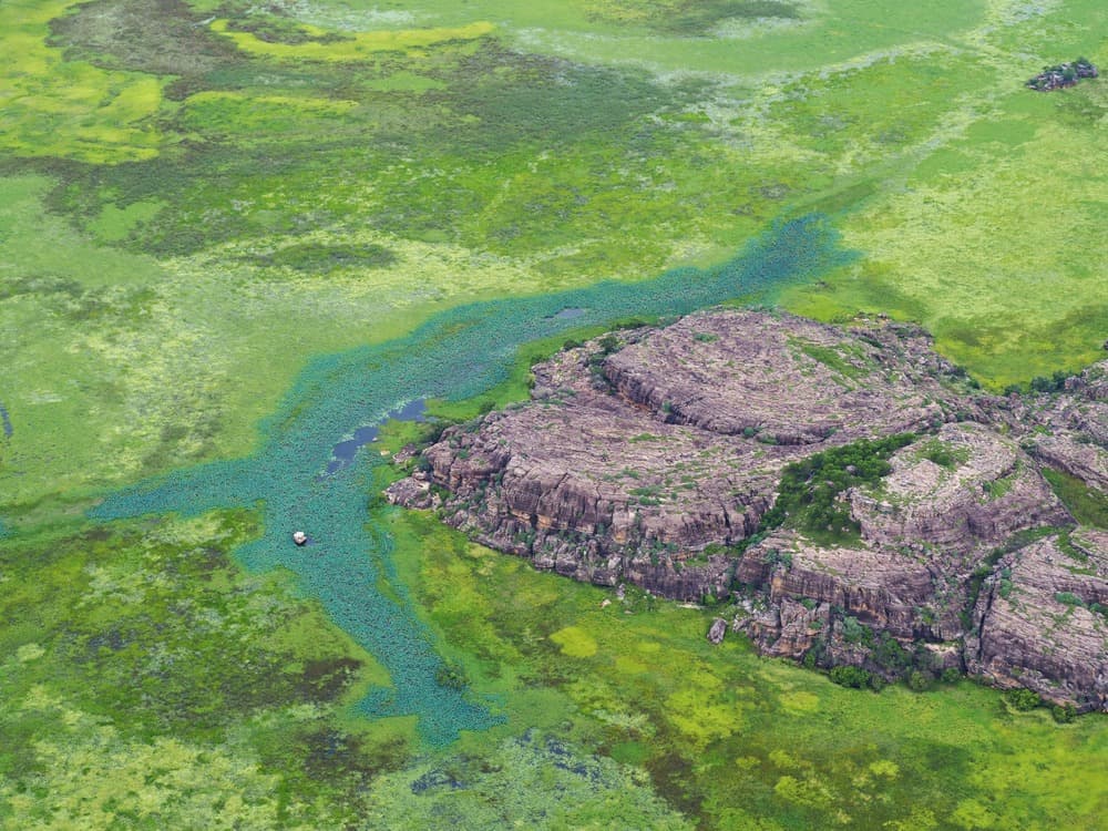
- Diverse landscapes: sandstone escarpments, savannas, mangroves, deserted beaches along the Gulf of Carpentaria and offshore islands.
- Dense wildlife including saltwater crocodiles, dugongs, sea turtles and exceptionally rich birdlife.
Tourism remains limited here: visitor numbers are low, infrastructure is basic, and most sites are visited with an Aboriginal guide or approved operator.
History and settlement
Arnhem Land is the territory of the Yolngu Aboriginal people for over 60,000 years, making it one of the oldest documented areas of continuous human settlement. Rock carvings and paintings scattered across the sandstone plateau bear witness to this occupation.
Long before European arrival, Macassans from Indonesia travelled along the Arnhem coast harvesting trepang (sea cucumber), which they later resold to Chinese markets. These seasonal contacts, documented from the 18th to early 20th century, left traces in Yolngu language, art and ritual practices.
The Dutch mapped the coast in the 17th century, and the territory takes its name from the Dutch ship Arnhem, which sailed along the region in 1623. European exploration of the interior, however, came much later: in the 1840s, Prussian explorer Ludwig Leichhardt was among the first Europeans to traverse Arnhem Land during his expedition to Port Essington. In the 19th century, Cobourg Peninsula briefly hosted the British colony of Victoria Settlement at Port Essington, whose ruins remain.
What to see and do
Gunbalanya and Injalak Art Centre
To the west, just after crossing the East Alligator River that marks the boundary with Kakadu, the community of Gunbalanya (Oenpelli) is home to the Injalak Art and Craft Centre. Here you can watch painters and weavers at work, and purchase works directly with proceeds returned to the artists. Local guides lead visitors up Injalak Hill, covered with rock paintings.
Mount Borradaile
To the north-west, Mount Borradaile houses an important collection of rock carvings and paintings, including representations of the Rainbow Serpent, a major figure in Dreamtime. Access is only via an approved lodge offering guided stays.
Gove Peninsula, Nhulunbuy and Yirrkala
To the east, the Gove Peninsula centres on the mining town of Nhulunbuy. The nearby communities of Maningrida and Yirrkala are major hubs of contemporary Aboriginal art. The Buku-Larrnggay Mulka Centre in Yirrkala showcases bark paintings and multimedia installations.
Cobourg Peninsula and Port Essington
The Cobourg Peninsula, classified as a national park and Ramsar site, stands out for its very low visitor numbers. Here you can reach the ruins of Victoria Settlement at Port Essington, remnants of a British colonisation attempt in the 1800s, usually accessed by boat or charter plane from a lodge.
Groote Eylandt Island
In the Gulf of Carpentaria, Groote Eylandt is renowned for big game fishing, managed by local operators. Access requires a specific permit issued by the Anindilyakwa Land Council.
Wildlife to observe
The region is home to the saltwater crocodile, found in both saltwater and freshwater environments, dugongs and several sea turtle species in coastal waters. For bird watchers, wetland areas host azure kingfisher, brolga crane, jacana, magpie goose and jabiru, among hundreds of recorded species.
When to go
The tropical climate divides the calendar into two seasons:
- Dry season (May to October): most accessible period, roads open, more moderate night temperatures. This is also peak tourism and cultural season (Garma festival at Gulkula in August).
- Wet season (November to April): lush vegetation, flowing waterfalls, but frequent flooding, some tracks impassable and cyclone risk. Always check road conditions before travel.
Practical information
Permits: a permit is compulsory to enter Arnhem Land outside transit zones. It is obtained from the Northern Land Council (west and centre) or Dhimurru Aboriginal Corporation (Nhulunbuy/Gove region), depending on your destination. Allow several days to several weeks processing time.
Safety: the presence of saltwater crocodiles requires extreme caution at all water sources, including far from the coast. Never swim without reliable local information.
Guided or independent travel: most visitors use an approved operator, which simplifies permits, logistics and access to cultural sites. Independent travel is possible with a 4x4 but requires serious preparation.
Budget: the region is more expensive than the rest of the Northern Territory (fuel, accommodation, internal flights). Budget above average Australian standards.
How to get there
- By air: daily flights connect Nhulunbuy to Cairns and Darwin, the main option for reaching eastern Arnhem Land.
- By car from Darwin: approximately 250 km to Jabiru via the Arnhem Highway, western gateway through Kakadu, then crossing the East Alligator River to Gunbalanya.
- By car from the south: the Central Arnhem Road joins the Stuart Highway south of Katherine and crosses the region from west to east to Nhulunbuy. Largely unsealed track, 4x4 essential, closed during wet season.
See nearby
- Kakadu National Park, immediate neighbour to the west, complementary for rock art and wetlands.
- Darwin, main logistical base to the north, with Crocosaurus Cove and Mindil Beach Sunset Market.
- Katherine and Katherine Gorges, to the south, on the alternative access route.
Frequently asked questions
Yes, for almost all of the territory. The permit must be obtained from the Northern Land Council or Dhimurru Aboriginal Corporation depending on your destination. Travellers going through an approved tour operator are usually covered by them.
The presence of saltwater crocodiles in the sea, estuaries and freshwater makes swimming potentially dangerous everywhere. Only swim at locations explicitly identified as safe by local communities or your guide.
For a first visit, a guided tour remains simplest: it handles permits, logistics and provides privileged access to cultural sites. Independent travel suits experienced travellers with a 4x4 who can plan authorisations well in advance.
May to October, in the dry season, when tracks are passable and the climate more temperate. The Garma festival in August is a prime time for Yolngu culture, but accommodation must be booked well ahead.
Allow a minimum of 3 to 4 days for a trip to Gunbalanya and Mount Borradaile, and a week or more to combine the west, Cobourg or Gove Peninsula with Kakadu.
Plan your trip to Australia
Arnhem Land naturally fits into a longer itinerary through the Northern Territory, complementing Kakadu, Litchfield and Katherine Gorges. To build a custom trip including this regulated-access region, explore our Australia tours.
Interested in this visit?
We can include it in your personalised itinerary.